Hey there, fellow farmers, ag tech nerds, and anyone stuck wondering why that buddy of yours keeps yapping about drones instead of tractors these days. Let’s cut through the hype—because when I’m chatting with folks at the drone farm supply shop I run, the number one question isn’t “are drones cool?” It’s “how the hell do these things actually fix my resource mess?” Like, I had a corn grower in Iowa hit me up last month saying he was wasting $12k a year on fertilizer that was just getting sprayed where it didn’t matter. That’s not “tech for tech’s sake”—that’s drones saving actual cash and sanity. Let’s break this down straight, no fancy jargon. Agricultural Drone
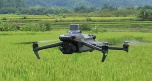
First off, let’s talk about the big one: fertilizer and herbicide waste. If you’ve ever sprayed a whole field like it’s a giant cookie cutter, you know what I mean. Dry patches? Weedy spots? Dead corn hiding in the rows? All that one-size-fits-all spray is just pouring money straight into the dirt that doesn’t need it. Drones don’t do that. Let me explain—our drones have these fancy little sensors (we call them multispectral, but don’t let the name freak you out) that pick up light we can’t see with our eyes. Healthy plants reflect green light, stressed ones push more red and near-infrared, and weeds glow a totally different hue. Last spring, a guy with 80 acres of soybeans told me he’d been spraying his entire field every two weeks for years, even though half of it was already thriving and only the edges had a few weeds. We sent a drone out, mapped the whole thing in 20 minutes flat, and he only sprayed the weed zones. He saved 30% on herbicide that season—no joke. And for fertilizer? Same deal. Those sensors tell you exactly where the soil is low on nitrogen, potassium, whatever—no more guessing. I’ve seen fields that used to get 200 pounds of nitrogen per acre only needing 140, because the drone mapped the dry spots and the already fertile areas. That’s $50 an acre back in his pocket, not spent on stuff that doesn’t help.
Next up: water. Water’s getting expensive everywhere, right? Drones are game-changers here, especially if you’re on drip irrigation or pivot systems. How? They can check soil moisture levels across a field in hours, not days. Back in the old days, you’d dig test pits in 5 random spots and assume the whole field was the same. That works if your field is perfectly flat, but half the farms I’ve seen have slopes, low spots, areas where water drains way faster. A drone’s thermal camera (yep, another sensor) picks up the temperature of the soil—drier soil is hotter, wetter is cooler. So instead of running your pivot 10 times when you only need to run it 6, you save water. A wheat farmer in Kansas I work with switched from guessing to drone-mapped irrigation two years ago, and he cut his water use by 25% in his first year. He said his water bill dropped $8,000 that summer alone. Also, no more wasting water on areas that don’t need it—those low spots that stay soggy after rain? The drone sees that too, so you can adjust your irrigation zones to skip them. That’s not just saving money—it’s good for the planet too, which is a win most farmers don’t hate.
Wait, let’s not sleep on seed allocation, either. If you’re planting, especially if you’re trying to adjust seeding rates for different parts of the field, drones make that way easier. Think about it: some parts of your field are super fertile, you can plant more seeds there for higher yield. Some parts are rocky, or get too much shade from trees, so planting as many would just be a waste of seed. Drones with imagery (we use RGB and multispectral here) map out those zones before planting season. Last year, a vegetable grower in Ohio grew peppers and tomatoes. His north field was shaded by a small forest, so he cut seeding rates by 40% there, and planted extra in the south field that got sun all day. He used 12% less seed overall, and the yield was actually higher in the shaded zone because he didn’t overcrowd the plants. No more buying 5 extra bags of seed that go bad in the garage every year—drones map the perfect seeding rate for every inch.
And here’s the part no one talks about a lot: labor and time. Let’s be real—farm work is brutal. If you’re out there walking 80 acres with a soil test kit, that takes days, and by the time you’re done, the weeds you saw at the start have already spread. Drones cover 100 acres in like 15 minutes, flight time is never more than 30 minutes per battery swap, and we set up the software so you get a map sent straight to your phone or laptop an hour after flight. Last month, a guy with a 200-acre corn field told me he used to hire two guys to walk and test soil over two weeks. Now he flies the drone, gets the map, and adjusts his fertilizer in a single afternoon. He saved the labor cost (which was around $3,000 for two weeks) and got the fertilizer on at the perfect time, so the corn absorbed it better. No more waiting for test results that take a week—you act now, when it matters.
Wait, but hold up—this isn’t just “buy a drone and magic happens.” I’m the supplier here, and I tell every single customer that: you need to know how to use the data. Our drones come with easy-to-use software, no complicated coding or anything. You plug in your field boundaries, pick what you want to map (soil moisture, weeds, fertilizer needs), and it does the rest. We also do little 15-minute tutorials for every customer, because I don’t want someone dropping $2k on a drone and then leaving it in the shed because they can’t figure it out. A lot of farmers I work with were skeptical at first—they thought this was just another gadget from some city guy who’s never picked up a pitchfork. But once they saw the numbers: saved $10k on inputs, less labor, higher yields? They’re hooked.
Let’s also talk about the not-so-obvious resource: your own time and peace of mind. How many nights have you laid awake wondering if you sprayed too much fertilizer, or forgot a spot where the weeds are taking over? Drones take that guesswork away. Last summer, a hay farmer in Minnesota hit me up saying he thought a third of his alfalfa field was dying. He flew a drone, and it turned out it was just a small patch of nematodes, not the whole field. He treated only that patch, saved himself from spraying the whole field for no reason, and didn’t lose half his hay. That’s the stuff that makes drones worth it—not just the cash, but not stressing every time it rains or a hot spell hits.
I should mention too, we work with all kinds of farms—small 40-acre family farms, big 1,000-acre operations. It’s not just for the huge guys. A couple weeks ago, a 50-acre vegetable farmer bought a used drone (we sell new and certified pre-owned, by the way) and he’s already cut his input costs by 18%. The biggest misconception is that drones are only for big ag corps, but no—even small farms can’t afford to waste resources these days, with input prices being all over the place.
Here’s the thing I always tell people: farming is all about working with what you have, not fighting it. The old way was brute force—spray everything, water everything, plant everything the same. Drones let you be smart about it. They turn “spray all” into “spray only where it’s needed,” “water all” into “water only the dry spots,” “plant all” into “plant where it’ll actually grow well.” That’s how you make every acre count, every dollar count.

If you’re a farmer who’s tired of throwing money at inputs that don’t move the needle, or spending all week testing soil and walking fields, we can help. We don’t just sell drones—we help you figure out exactly what you need for your specific operation, whether you’re growing corn, soy, veggies, hay, whatever. We can set you up with the right sensors, the software that’s easy to use, and even connect you with local folks who can help if you get stuck. No pushy sales stuff, just real talk for real farmers. If you want to chat through how drones could help you cut waste, save time, and make more money, reach out and let’s hash it out. We’re here to make ag tech work for you, not the other way around.
Fpv Drone References:
- Agricultural Drone Association. (2023). Resource Allocation Efficiency in Modern Precision Agriculture.
- University Extension, College of Agriculture. (2022). Precision Irrigation and Input Management Using Unmanned Aerial Systems.
- Farm Journal Ag Tech Report. (2023). Economic Impact of Drone-Based Variable Rate Applications on Row Crops.
- International Society of Precision Agriculture. (2022). Soil Mapping and Seeding Rate Optimization Using Multispectral Drone Imagery.
- U.S. Department of Agriculture. (2023). Reducing Agricultural Input Waste Through Precision Technology Adoption.
Shandong Lesong Drone Technology Co., Ltd.
As one of the most professional agricultural drone manufacturers in China, our products have good reputation in the market. Please rest assured to wholesale high quality agricultural drone for sale here from our factory. Good service and punctual delivery are available.
Address: Yuncheng County, Heze City, Shandong Province
E-mail: Ella36988@163.com
WebSite: https://www.china-uavfactory.com/
